

Unlocking Urban Insights for smarter cities
Instantly assess accessibility, plan smarter, and shape vibrant communities. Find out how UrbanAccess revolutionises urban planning for a brighter tomorrow.

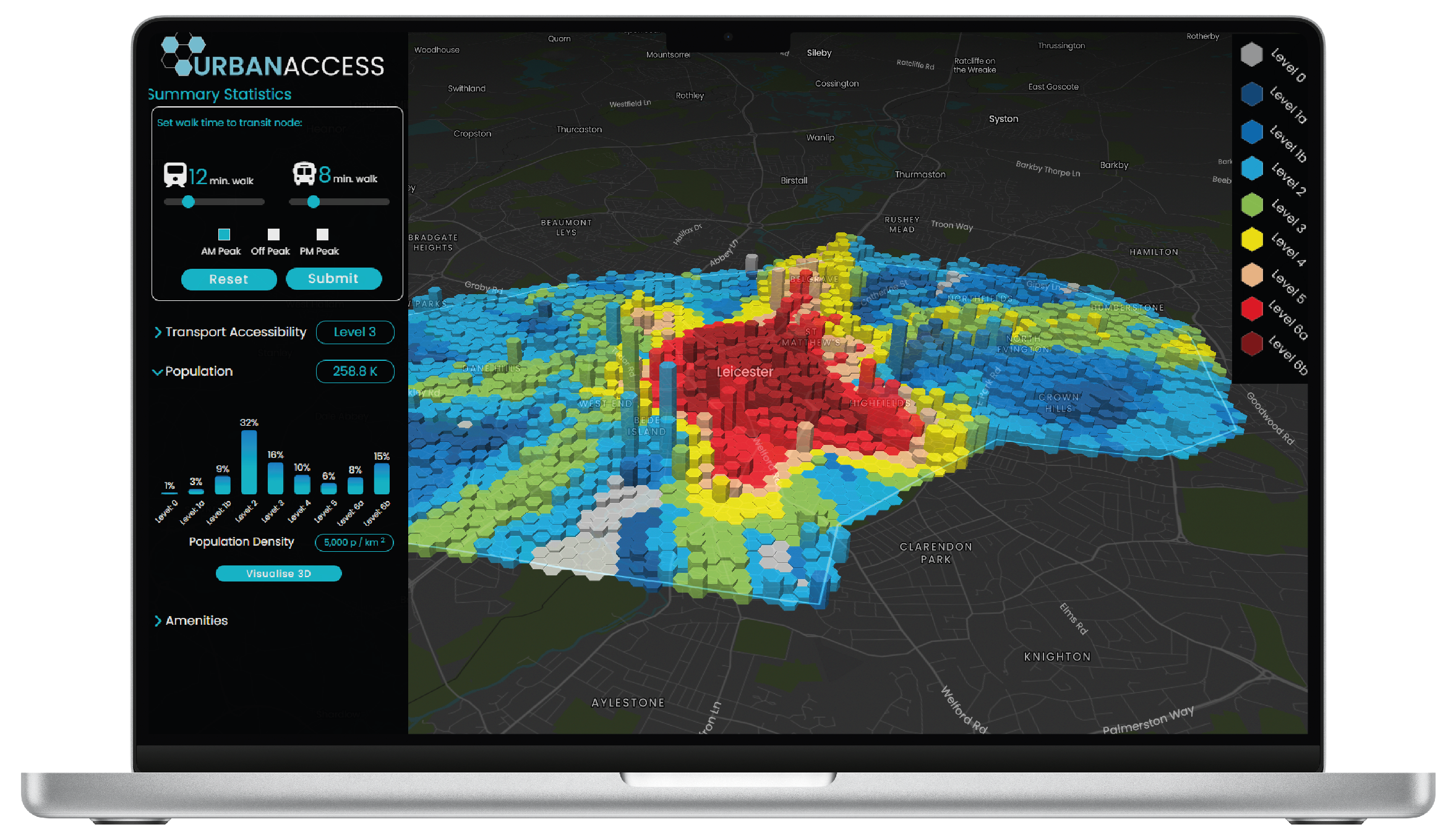
Unlock the power of instant public transport accessbility
Understanding transport accessibility is paramount in urban masterplanning as it serves as the backbone for sustainable development and equitable access to resources and opportunities within a city. Efficient transport systems facilitate the movement of people and goods, reducing congestion, pollution, and travel time.

Instant Analysis
With Urban Access, you can instantly assess public transport accessibility by factoring in service frequency, wait times, walk times, and reliability. Say goodbye to data cleaning, timetable formatting, and GIS analysis—this platform delivers fast and effective results, streamlining urban planning decisions effortlessly.

GTFS Data Download
Urban Access has streamlined GTFS data handling. From urban planners to GIS analysts, this platform facilitates fast and efficient data downloads for seamless integration into other GIS platforms. No more formatting headaches, just smooth data acquisition with Urban Access.

Reports
Our app swiftly generates styled reports on transport accessibility, offering both high-level overviews and detailed location-specific insights. Impress clients with professionally designed reports that showcase key metrics and trends, empowering decision-makers with actionable information.
Tap into Urban Development Potential with Population Density Analysis
Our population density analysis tool provides valuable insights for urban planning, helping you make informed decisions.
Identify High-Density areas
Pinpoint areas suitable for mixed-use development
Locate possible sites for new transit or micromobility hubs.
Get a breakdown of population and accessibility level
Evaluate Nearby Amenities with our Liveable Neighbourhoods tool

Utilise our Liveable Neighbourhoods tools to construct your ideal community, dynamically assessing locations based on your needs, and identifying amenity gaps for urban designers to enhance local communities
Analyse for Retail, Health, Education, Food & Drink, Culture, and Recreation
Isolation of each category to identify gaps
Multimodal assessment capability
Analysis for 5-20 minute cities optimisation
How it works
Dive into the intricate mechanics of UrbanAccess, where data meets seamless integration, empowering urban planners with unparalleled insights into accessibility, amenities, and urban dynamics.
Public Transport Access
Measure public transport accessibility precisely, in seconds.

Adjustable Parameters
Adjust walk times to key transit stops

Service Frequency
Understand service frequency for effective planning purposes

Liveable Neighbourhoods
Analyse key amenities in your study area. (15-minute cities).

Comprehensive Insights
Understand population density, accessibility, and amenities in your area quickly.

Easy GIS Integration
Integrate GTFS feeds and PTAL results seamlessly to GIS using H3 grid system.

Location-Specific Scores
Access PTAL scores customised to each location.

Custom Summary Reports
Download summarised reports for specific locations.


Time is Money? Save both with URBANACCESS
Urban planning just got a makeover – with UrbanAccess leading the charge. Say goodbye to antiquated methods and hello to a future where time and money are no longer obstacles but your greatest allies.
Time Saved
Enjoy a remarkable 80% reduction in time compared to traditional methods.
80%
95%
Cost Savings
Achieve approximately 95% savings compared to conventional approaches
FAQs
Find answers to common questions about our product, subscriptions, data and payment methods
-
Transport accessibility refers to the ease with which people can reach various destinations using transportation modes such as public transit, walking or cycling. It encompasses factors such as the availability, frequency, reliability, and affordability of transportation options, as well as the physical infrastructure and connectivity of transportation networks. High transport accessibility means that people have convenient and efficient access to essential services, amenities, employment opportunities, and social activities, contributing to overall mobility, quality of life, and economic development.
-
A 15-minute city is a urban concept where all essential services, amenities, and daily needs are accessible within a 15-minute walk or bike ride from one's home. The idea is to create compact, self-sufficient neighborhoods where residents can easily access grocery stores, schools, workplaces, parks, healthcare facilities, and cultural or recreational venues without the need for long commutes or reliance on cars. By reducing the need for extensive travel and promoting active transportation, 15-minute cities aim to improve quality of life, sustainability, and community cohesion.
-
GTFS, which stands for General Transit Feed Specification or (originally) Google Transit Feed Specification, defines a common format for public transportation schedules and associated geographic information.
-
UrbanAccess uses 4 data sources:
GTFS Feeds for Bus and Lightrail in the UK
GTFS Feeds for Heavy Rail
OpenStreetMap - Amenities
TfL Accessibility Method -PTAL Methodology
-
Developed in 1992 by a West London borough, the Public Transport Accessibility Level (PTAL) method is a measure of how well-served different areas are by public transport.
Simplify Urban Planning with URBAN ACCESS
Unlock the power of data to create accessible and thriving cities.